


Forum topic: More details of the Broomfield Park wetlands proposals
More details of the Broomfield Park wetlands proposals
PGC Webmaster
02 Aug 2017 17:25 #3152
- PGC Webmaster
-
 Topic starter
Share
![]()
![]() Share by email
Share by email
Enfield Council and Thames 21 have now published a more detailed version of their proposals for a wetlands scheme in Broomfield Park, designed to produce environmental benefits both locally and in the rivers Lea and Thames. There will be a consultation event in the park on 12th August or you can give your views online or by post.
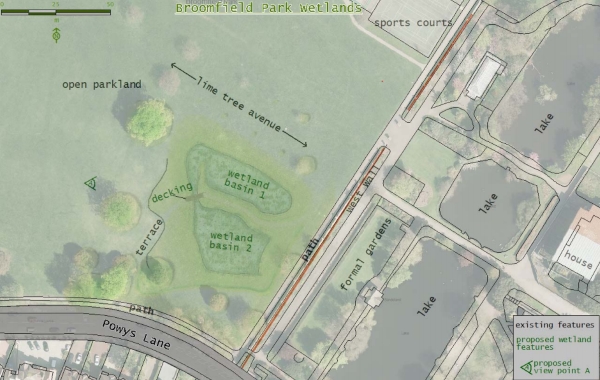
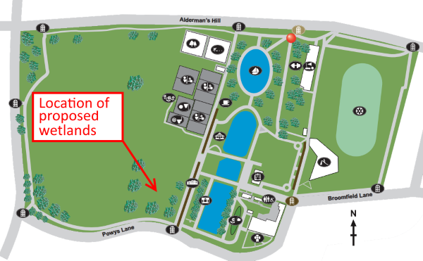 The wetlands area would be at the southern end of the park, on part of the "top field" in the vicinity of the historic brick wall. It would consist of two interjoined "basins" or "cells" with a decking bridge over the connecting area.
 The total area of the cells would be approximately 1500 square metres, equivalent to the five tennis courts. The water would be shallow - only 300 millimetres.
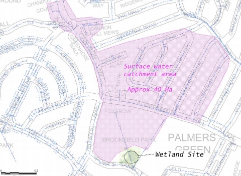
The wetlands would be created by diverting the flow from an underground surface water sewer, which flows beneath the park, draining a 40 hectare catchment to the north.
The proposal is similar, but not identical, to the recommendations of the Conservation Management Plan for Broomfield House and Park which was developed in association with efforts to gain funding to restore the burnt out house:
58 – Reinstate original drainage ditch along southern boundary to address waterlogging of parkland. Allow to develop as ecological habitat, natural SuDS
The ditch referred to here at one time ran alongside the north side of Powys Lane.
The area would be planted with reeds, marginal flowers and grasses, and the new habitat should attract amphibians, insects and birds.
Benefits of the wetlands scheme
The scheme would have several benefits:
- reduced risk of flooding in the local area and downstream along the Pymmes Brook - achieved by increasing the volume of flood waters retained in the wetlands
- improved water quality in the Pymmes Brook catchment as a result of natural filtration
- improved drainage of some areas of the park that become waterlogged
- additional biodiversity (plants and animals)
- an attractive and interesting area for visitors to the park.
Consultation arrangements
The second of two drop-in consultations events will take place on Saturday 12th August (10am to 3pm near the Greenery cafe). Visitors will be able to fill in a questionnaire. Alternatively, visit this page on the council website and follow the links to download a detailed consultation document.
The closing date for responses is Friday 15 September 2017.
If you have any queries or require assistance to participate in this consultation, you can email and .
Please Log in or Create an account to join the conversation.
More about flood alleviation and sustainable drainage
PGC Webmaster
02 Aug 2017 22:37 #3153
- PGC Webmaster
-
Topic starter
Share
![]()
![]() Share by email
Share by email
They have a green gazebo (obviously) and will be there from Noon to 6pm. You can follow them on Twitter @EnfieldSuDS.
The Enfield Local Flood Risk Management Strategy was updated last year and can be found at new.enfield.gov.uk/services/environment/rivers-and-streams/flood-management/flooding-information-local-flood-risk-management-strategy-2016.pdf .
Please Log in or Create an account to join the conversation.