


Forum topic: Rear garden on Lakeside Road flooding A LOT lately (after rain)
Rear garden on Lakeside Road flooding A LOT lately (after rain)
Michael O'Connor
21 Feb 2021 20:31 #5896
- Michael O'Connor
-
 Topic starter
Share
![]()
![]() Share by email
Share by email
Anyway yes, I live on Lakeside Road N13 (Lakes Estate) around a 3rd of the way up the road. I've noticed lately the bottom of the rear garden has been flooding massively! It has always gotten a little soggy as the garden is on a very gentle, barely visible incline and it dips down a little around 3 quarters of the way down, then back up, but it's never been this water logged.
Now, every time it rains that dip 3/4 of the way down fills with around 4 inches of water, and the water also runs about halfway back up the garden too. No work has ever been done in the garden. The garden dries out somewhat, but it will stay flooded like that and take a very long time to drain, for at least 2 days after rain.
I'd say it's only been flooding this much in the last 3-4 months. I fear it may have something to do with a burst or blocked pipe under the garden; coincidentally Thames Water have been doing work on the water pipes in these roads in the last few months so it would seem to coincide with this. There is also a very large tree on the left side of the garden, near the bottom, the roots of which have pushed up a lot of the paving down the left edge of the garden. I'm thinking maybe a root has damaged a pipe. We haven't experienced any problems with water pressure inside the house (although that would only mean that the pipes serving our house our fine), it doesn't necessarily rule out the possibility of a damaged pipe under the garden.
Has anyone else had any experience of this happening? Thanks
Please Log in or Create an account to join the conversation.
Rear garden on Lakeside Road flooding A LOT lately (after rain)
Ulric von Bek
22 Feb 2021 14:19 #5897
- Ulric von Bek
-
Share
![]()
![]() Share by email
Share by email
Please Log in or Create an account to join the conversation.
Rear garden on Lakeside Road flooding A LOT lately (after rain)
Colin Younger
22 Feb 2021 17:58 #5898
- Colin Younger
-
Share
![]()
![]() Share by email
Share by email
It may be different if you were at the bottom of Derwent Road, where the houses were built over the large lake which was there, and cellars might still flood.
Please Log in or Create an account to join the conversation.
Rear garden on Lakeside Road flooding A LOT lately (after rain)
Ulric von Bek
22 Feb 2021 20:03 #5899
- Ulric von Bek
-
Share
![]()
![]() Share by email
Share by email
Please Log in or Create an account to join the conversation.
Rear garden on Lakeside Road flooding A LOT lately (after rain)
PGC Webmaster
24 Feb 2021 22:46 #5903
- PGC Webmaster
-
Share
![]()
![]() Share by email
Share by email
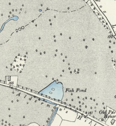
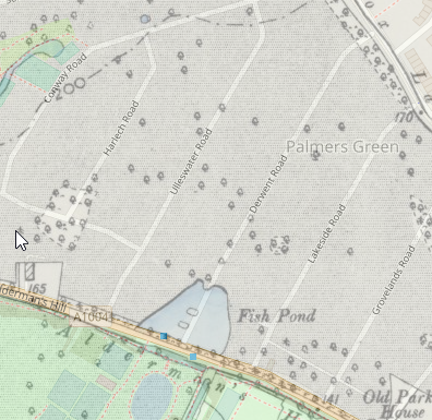
I've copied the relevant area with and without the modern map showing. As you can see, Derwent Road goes right over the top of the former pond, but Lakeside Road misses it.
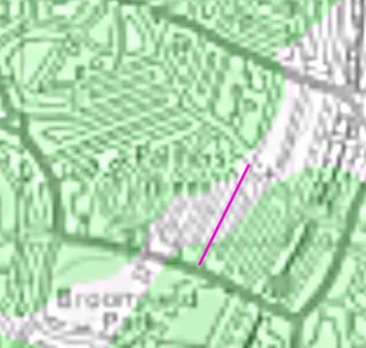
I've also looked at a modern map of groundwater flood risk in the borough and superimposed a street map on top of it.
If Im correct in my assumption that the green shading shows areas at risk, It turns out that large parts of Palmers Green are in the flood risk area (probably less of a worry than being at risk of surface water flooding). You can find the map at the end of this document: www.planvu.co.uk/enfield/written/dmd/appendix.php
The pink line is Lakeside Road. Only a small part of Lakeside Road is in the flood risk area - is this where the house in question is located? Unless of course, my assumption about the meaning of the green is wrong.
There's probably enough of interest in this old map archive to see us through another year of lockdown!
Please Log in or Create an account to join the conversation.