Links
School Streets information on Let's Talk Enfield website
Link to traffic management order implementing the new school streets
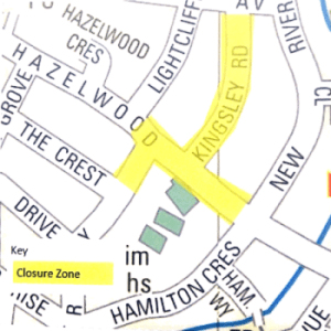
Important information regarding the proposed Hazelwood School Street on Kingsley Road, River Way and Hazelwood Lane
Dear resident, business owner or parent,
Following the successful implementation of 14 School Streets across the borough, Enfield Council are expanding the initiative to more schools and are proposing a School Street on Kingsley Road. River Way and Hazelwood Lane, as shown on the map overleaf, for Hazelwood School.
A 'School Street' is an area transformed into a pedestrian and cycling zone operating Monday to Friday during the school term, during set times at drop-off and pick-up times. School Streets aim to:
- ensure the safety of school students as they arrive to and leave school,
- improve the air quality near the school, and
- encourage more young people to walk and cycle to school.
When the School Street zone is in operation during the designated hours, motor vehicles cannot pass through the zone, except for those who have applied and received a permit or exemption. Those who are eligible for exemptions include:
- residents who live within the zone,
- Blue Badge holders requiring access to the school (for example parents who hold a Blue Badge for a pupil),
- school staff who have been provided a permit by the school administration under exceptional circumstances,
- businesses who operate within the zone, and
- emergency services.
Further information on School Streets and how they operate can be found at https://letstalk.enfield.goy.uk/schoolstreets.
Share your views
In partnership with Hazelwood School, Enfield Council is proposing a School Street as shown in the map overleaf and detailed in the proposed traffic order found at the link above. The proposed times of operation are 8.15am to 9.15am, and 2.45pm to 3.45pm from Monday to Friday during the school terms only and will be enforced by a camera operated system.
We invite residents, businesses, parents, school staff and any other interested stakeholders to take part in the statutory consultation by Sunday 19 June 2022. Please make your representation or objection in writing stating the grounds on which it is being made and quoting the reference TG1500 no later than 11.59pm on Sunday 19 June 2022. You can write to us in any of the following ways:
- via the survey at https://letstalk.enfield.gov.uk/SchoolStreets
- by email to , or
- in writing to Healthy Streets, Enfield Council, Silver Street, Enfield, EN13XA.
All comments received during the consultation will be considered. We are not able to respond to individual comments, however a report that summarises the findings of the consultation will be published in due course.
Kind regards,
Penny Swan
Project Manager
Healthy Streets team
Enfield Council
Source: Leaflet delivered to homes in and near Hazelwood Lane
List of proposed new school streets
|
Pedestrian and cycle zone |
Streets or lengths of street to be included |
Proposed hours of operation |
Enforcement |
|
Bowes Primary School |
Highworth Road N11, from its junction with Union Road to its junction with A406 North Circular Road |
8.30am to 9.15am and 3.00pm to 3.45pm |
ANPR |
|
Hazelwood Primary Schools |
Hazelwood Lane N13, from its junction with Lightcliffe Road to its junction with New River Crescent; |
8:15am to 9:15am and 2:45pm to 3:45pm |
ANPR |
|
Houndsfield Primary School (Permit PCZ18) |
Cleveland Road N9; Doncaster Road N9; Houndsfield Road N9. |
8:30am to 9:30am and 2:45pm to 3:45pm |
ANPR |
|
St James C. of E. Primary School (Permit PCZ15) |
Frederick Crescent EN3. |
8:15am to 9:15am and 2:45pm to 3:30pm |
Manual |
|
St Mary's Catholic Primary School (Permit PCZ16) |
Durants Road EN3, from its junction with Bursland Road to its junction with Alexandra Road. |
8:15am to 9:15am and 2:30pm to 3:30pm |
Manual |
|
Wilbury Primary School (Permit PCZ17) |
Weir Hall Road N18, from its junction with Wilbury Way to outside No. 90 Weir Hall Road. |
8:30am to 9:15am and 2:45pm to 3:30pm |
ANPR |