![]() Enfield Council has this week launched consultations about two new walking and cycling routes which are proposed as part of the borough's Journeys & Places Programme:
Enfield Council has this week launched consultations about two new walking and cycling routes which are proposed as part of the borough's Journeys & Places Programme:
The initial consultation phases will use interactive maps, allowing people to type in their ideas and their concerns relating to particular points along the routes. There will also be webinars (online briefings and question and answer sessions). The Enfield-Ponders End consultation runs until 12th February, the Bridport Road consultation until 19th February.
Enfield Town to Ponders End Station
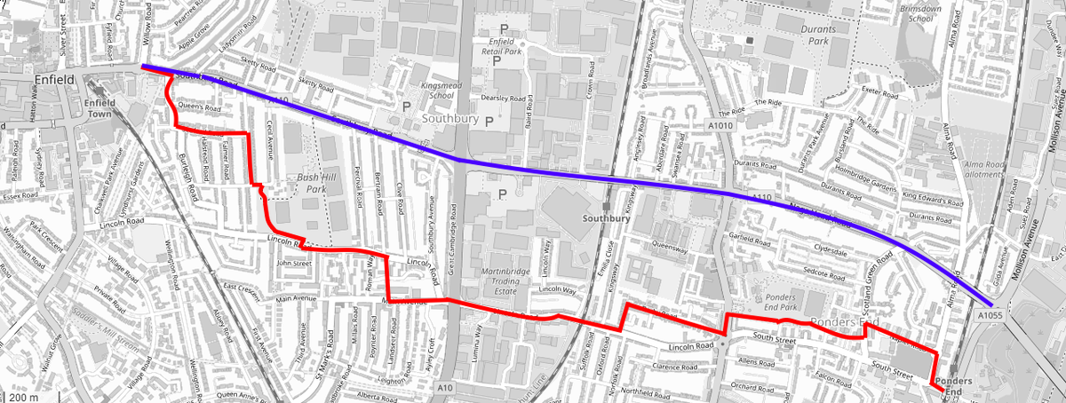 The proposed new cycling route from Enfield Town to Ponders End (red line) is very different from the direct cycle lanes (blue line) that the council was planning in 2013
(Click on the map to enlarge)
Cycle lanes between Enfield Town and Ponders End along the A110 (Southbury Road and Nags Head Road) were an integral part of Enfield Council's bid to the Mayor of London for "Mini-Holland" funding in 2013, forming one of three "cycle corridors" shown in this map that was published in 2014. The two other "corridors", along the A105 (Palmers Green to Enfield Town) and the A1010 (Fore Street/Ponders End High Street/Hertford Road), are now complete. However, the only improvement in prospect for the A110 currently (and that will depend on funding) is the promised cycle lanes along Cecil Road, which form part of the Enfield Town Improvement Project - the plan for cycle lanes along the A110 east of Enfield Town was abandoned several years ago on the grounds that they would reduce capacity for motor vehicles to an unacceptable degree.
The council's new proposal to link Enfield Town and Ponders End involves a much more complicated route running to the south of the A110. As well as being longer, the number of turns in the route will slow down journeys. Furthermore, as proposed, the route includes sections running through Bush Hill Park and Ponders End Park, which are likely to deter both pedestrians and bike riders after dark.
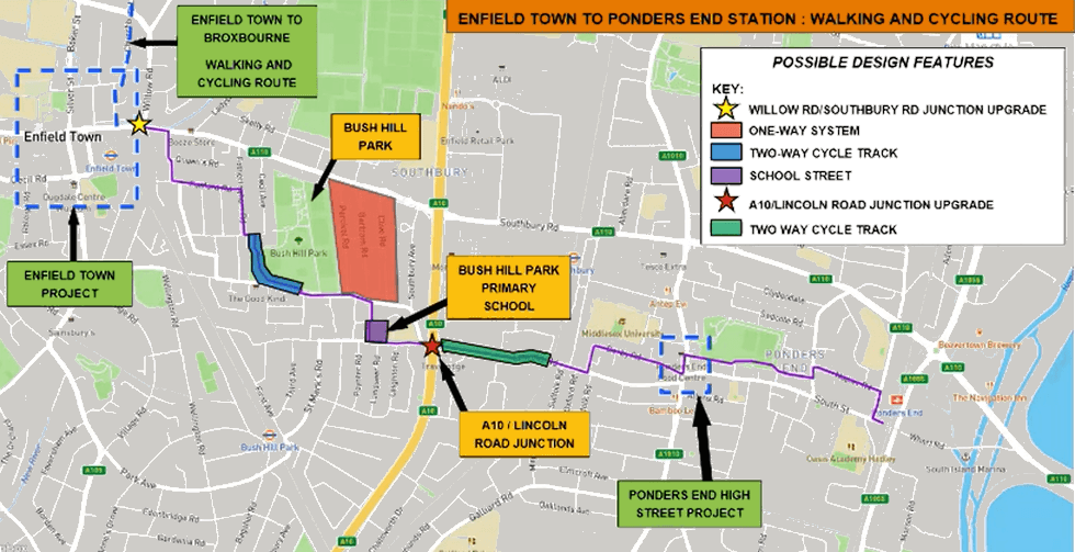
Apart from mapping out the route, the council has not at this stage said anything definitive about what measures will be used at which points along the route. These are what they say are under consideration:
Possible interventions based on other similar routes may include:
- Cycle lanes (mandatory, advisory, segregated or stepped) in a bidirectional or with-flow arrangement.
- Crossings (pedestrian/cycle or both)
- Footway widening
- Modal filters
- Point closures
- One-Way working
- Banned turning movements
- Changes to/addition of traffic signal junctions
- Changes to parking and loading arrangements
- Rain gardens and landscaping
- School Street
- Cycle parking
The fact that the route makes diversions to avoid using obvious stretches of Lincoln Road and South Street suggests that the council wish to minimise creation of proper segregated cycle lanes. However, this will increase the probability of cyclist-motorist conflicts and slow down journeys by bike. Bear in mind that Enfield Town to Ponders End is part of a key west-east route, giving access to one of only two non-motorway bridges across the River Lea in the borough, so cyclists making longer journeys will be using it.
Great Cambridge Junction to Bridport Road (Upper Edmonton)
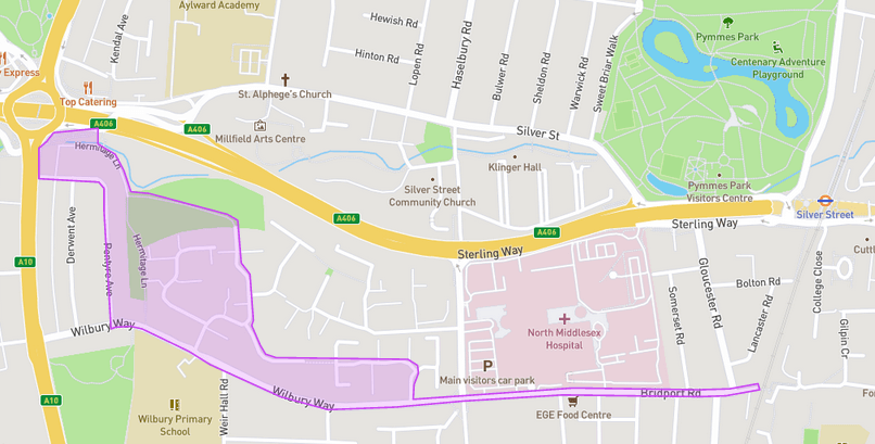 The interactive map for the second walking and cycling route consultation suggests that the council is open to various suggestions for how to link the Cambridge Roundabout cycle underpasses to the junction of Wilmer Way and Bull Lane
"Great Cambridge Junction" is a new name to me for what I've always called the Cambridge Roundabout (which was named after the former Cambridge pub, not the Great Cambridge Road). Bridport Road runs west-east along the southern boundary of the North Middlesex Hospital site (in effect, a continuation of Wilbury Way).
This route will connect the active travel route on Grove Street, which is currently under construction, with the North Middlesex Hospital Active Travel Improvements project (Cycleway 1) and onwards with the existing A10 cycle facilities and the cycle facilities under the Great Cambridge Roundabout (junction of A10 with A406).
As such, it will make a valuable addition to the growing network of more local active travel routes. I've actually used the same route to reach the North Mid from home on foot two or three times and would welcome improvements at various points along the way.
More information
Enfield Town to Ponders End Station walking and cycling route
- Project page on Let's Talk Enfield website
- Interactive map of proposed route
- Link to webinar (6pm Monday 23rd January)
Great Cambridge Junction to Bridport Road walking and cycling route
- Project page on Let's Talk Enfield website
- Interactive mape
- Letter to residents and business owners
- Link to webinar (6pm Thursday 2nd February)

